How geoscience data can shape the future of mining
Excitement in the mining industry is building about the digital mine. The future of mining – and the future of geology – is being shaped by advances in technology and the industry’s willingness to embrace these changes.
..
- Big data, big data management problems
- More mine sites, more technology and more data
- Evolution of systems thinking in mining
- The case for integrated data capture
- GIM Suite – Acquire’s Information Management Solution
- Early adopters are well-placed for the future of mining
One of the driving forces of the digital mine concept is access to better data, from more sources, and in a shorter time frame. Data collection – and how we manage original observations and measurements over the history of a mine – determines whether geoscientific information becomes a fundamental link in the mining value chain or remains a collection of disparate data points.
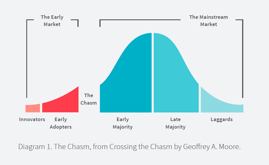
The mining industry is still in the Early Market phase of the technology adoption curve [see diagram 1] and, from a data collection perspective, must cross the chasm from manual, old-school ways to an environment where sensors dominating the data collection landscape are mainstream.
Big data, big data management problems
Miners are experiencing a deluge of real-time data coming from sensors in every type and part of equipment used in the mining environment. Large volumes of data are being generated around the clock, sometimes arriving with errors, duplicate information, and missing or incomplete data. In some areas, the volume of machine- and sensor-generated data now greatly exceeds the amount of human-generated data, a trend only expected to increase over time.
The current environment for data collection highlights an increasing number of data sources with no persisting common threads holding the data together. In the geoscience context, these missing common threads can include sampling locations, drillhole identifiers and the relationships between identifiers. New datasets exist in isolation, resulting in the emergence of data quality and consistency issues which ultimately degrade the overall value that sensor data provides.
More mine sites, more technology and more geoscience data
There is an expectation on geologists and other professionals to generate models and make decisions using these fragmented datasets – which includes the trusted data already collected over the evolution of the asset. Geologists are managing a complex web of data but have less certainty about the quality of their data than before the advent of the digital mine.
The problem is compounded when dealing with multiple mine sites and/or commodities. Add in the complexities of modern exploration, which often happens in areas of low connectivity, and the promise of the digital mine begins to feel unrealistic.
Evolution of systems thinking in mining
The majors are beginning to view their entire organisation from a single lens – from exploration through to mining and processing execution activities. How we select, collect, validate and integrate data from all these new sources becomes critical to the future of mining. Geoscientific data management has to be included into the systems thinking for any organisation considering how to benefit from the future of digital mining.
The case for integrated data capture
Miners are struggling to connect related geoscientific data from disparate sources in an efficient and timely manner. With little evidence to suggest an established technology path at an industry level, systems thinking is more important than ever.
Treating data sources as an integrated network provides a reliable approach for miners contemplating how they can harness the burgeoning opportunity. It takes a whole-system view of data and brings order to the current chaos of data sources, data types and disconnected information to create a single source of truth for geoscientific information. What does integrated data capture look like?
- Less manual intervention – Applying business rules throughout the mining value chain ensures more dependable and durable data capture.
- Less costly data capture – Interoperability and the integration of systems makes data capture more reliable and quicker, with less time spent on manual processes and managing custom routines.
- Easier offline field data capture – Internet connectivity is not a requirement for remote data collection.
- No requirements for special equipment – Data capture occurs on the same mobile devices people use in everyday lives.
- Minimal training required for end users – No specialised training needed to log samples.
- Single, trusted source of geoscientific data – All geoscientific data is stored in one place, regardless of the source.
GIM Suite – Acquire’s Geological Information Management Solution
One solution that ticks all the boxes is Acquire’s Geological Information Management Solution – GIM Suite. With more than 450 GIM Suite installations throughout the world, including all the major miners, we have been working on our roadmap to the digital mine of the future for the better part of 10 years. All we’ve learned is in GIM Suite, which is available across desktop, web and mobile.
Early adopters are well-placed for the future of mining
As with any new innovation, recognising an opportunity and taking smart steps early on can have a huge impact on future efficiencies and costs. In the case of geoscientific data management, early adopters of integrated data capture put themselves on the path to the digital mine of the future.
If you would like more information about how GIM Suite can help you, send us an email. We’ll schedule a meeting to discuss your current data collection environment and explore how your company can benefit from integrated data collection as you transition to the mine of the future.
About the author
 Steven Mundell is the Director of Product at Acquire and an all-around nice guy. Before he joined Acquire in 2002, Steve worked as an underground mine geologist. His research interest in information management for the natural resources industry guides the product development for Acquire’s next-generation geoscientific information management software.
…